The content is loading
Period:
ENSO Outlook: April 2026
This page considers the ENSO outlook for the next three to six months, and the typical impact of El Niño and La Niña events on rainfall in Southeast Asia.
Current SST conditions are shown on the climate monitoring node website: sst - SEA Climate Monitoring
Latest Climate Outlook (December 2025 – May 2026): La Niña conditions expected into DJF 2025/2026, global climate models predict transition into ENSO-neutral conditions subsequently
Updated: Oct 2025
Recent analysis of sea surface temperatures (SSTs) were below-average across the central and eastern equatorial Pacific Ocean and, along with atmospheric indicators such as stronger trade winds and increased cloudiness in the western Pacific, indicate La Niña or La Niña-like conditions.
International climate outlooks predict weak or moderate La Niña conditions for December 2025 to February 2026. After DJF 2025/2026, most models indicate a transition from La Niña to ENSO-neutral conditions, although there remains a possibility that La Niña may persist beyond early 2026.
Latest Model Outlook
Model outlooks from Copernicus C3S (Figure 1), based on the Relative Nino3.4 SST index, predict the index to continue warming, with the ENSO-neutral conditions very likely to persist until May 2026. From June – July 2026, models predict El Niño conditions as the dominant phase, although there is still a chance for neutral conditions to continue. For those predicting El Nino conditions, models predicting the strength to be moderate to strong. However, there is still considerable uncertainty in the long-term forecasts at this time of the year, therefore the strength of the predicted El Niño conditions is uncertain.
Figure 1: Forecasts of Nino3.4 index’s strength until September 2026 from various seasonal prediction models of international climate centres (image credit: Copernicus C3S).
Impact of El Niño/La Niña on Southeast Asia
The typical impact of El Niño on Southeast Asia is drier-than-average rainfall conditions, including for much of the Maritime Continent during December to February (Figure 2, left). Warmer temperature conditions typically follow drier periods.
The opposite conditions for rainfall (and consequently temperature) are observed during La Niña years (Figure 2, right).
The impact on the region’s rainfall and temperature from ENSO events is more significantly felt during strong or moderate-intensity events. Also, no two El Niño events or two La Niña events are exactly alike in terms of their impact on the region.

Figure 2: December to February (DJF) season rainfall anomaly composites (mm/day) for El Niño (left) and La Niña (right) years. Brown (green) shades show regions of drier (wetter) conditions. Note that this anomaly composite was generated using a limited number of El Niño and La Niña occurrences between 1979 and 2021 and therefore should be interpreted with caution (data: The Global Precipitation Climatology Project (GPCP) Monthly Analysis Version 2.3).
The impact on the region’s rainfall and temperature from ENSO events is more significantly felt during strong or moderate-intensity events. Also, no two El Niño events or two La Niña events are exactly alike in terms of their impact on the region.
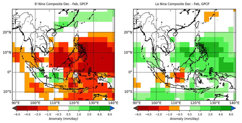
Figure 2: December to February (DJF) season rainfall anomaly composites (mm/day) for El Niño (left) and La Niña (right) years. Brown (green) shades show regions of drier (wetter) conditions. Note that this anomaly composite was generated using a limited number of El Niño and La Niña occurrences between 1979 and 2021 and therefore should be interpreted with caution (data: The Global Precipitation Climatology Project (GPCP) Monthly Analysis Version 2.3).
The qualitative outlook is assessed for the region in general. For specific updates on the national scale, the relevant ASEAN National Meteorological and Hydrological Services should be consulted.